
Construction
Perform continuous follow-ups on construction work with underwater drones
Explore products Talk to an ROV expertIncreased control in construction projects with underwater drones
A lot of construction work takes place near or in water. Both the construction of ferry lanes, bridges and roads require a good overview of how the construction affects the surrounding area and vice versa.

Industrial reliability
The Blueye drone is designed to satisfy industrial reliability requirements, while maintaining unprecedented user-friendliness.

Quick deployment
Deploy within minutes and perform your inspections efficiently to optimize your resources.

Digital workflow
Get clear visuals and vital data directly to your device. Share findings with colleagues and upload to your reporting system. Streamline the inspection process.
Webinar - 3D PHOTOGRAMMETRY USING UNDERWATER DRONES
In this webinar we're sharing insights on photogrammetry in general and how 3D models can be built with footage from underwater drones.
The Blueye drone is easy to use and doesn't demand much training. It's also an advantage that everything is battery driven, it gives me more mobility.
Joakim Myren
Project Engineer, NRC Group


Blueye Cloud
Follow the work below the waterline, week by week
When you build ferry quays, bridges and pipelines, much of the work has to be checked under water, often in poor visibility. Blueye Cloud collects the dives from each site visit in one project for the job, keeps the video and photos in one library, and drafts the report for the client.
- Keep the dives from every site visit in one project per job, with the drawings attached
- Narrate as you dive, then search the transcript for the clip of a flange or drill hole
- Draft the progress report with AI, each finding linked to the moment in the video
- Turn dive video of a pipe joint or rock face into a 3D model you can measure in the browser
Blueye Cloud is hosted in Europe

Scour protection missing around piles P14–P16 on the south side
Projects. Gather dives, findings, documents and map layers in one project, and share it with a link instead of a PDF. Pro
Documentation of the 18 new steel piles before the deck is cast. No visible damage on piles P1–P18, and the scour protection is in place on the north side.
Scour protection missing around piles P14–P16 on the south side — complete before casting.
AI reports. Draft an inspection report from the dives, transcripts and photos. Every finding links to the moment it came from. Pro
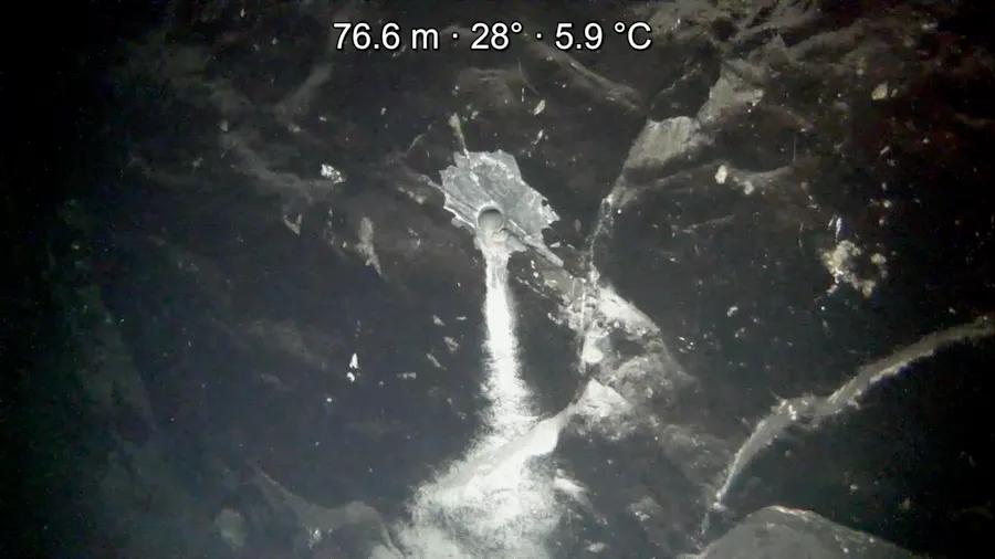
Probe-drill hole in the rock face at 77 m, with fine sediment running from the opening; no loose rock around the hole.
AI photo captions. One click and the vision model describes the photo and suggests tags from your own catalogue. You approve before it is saved.
3D models
Turn dive video into a 3D model
Pick the videos of a propeller, a wreck or a pier footing and press Build. Blueye Cloud picks keyframes using the dive log, reconstructs the scene and adds a textured, true-to-scale 3D model to the project.
- Built from the drone videos and dive logs you already upload — no photogrammetry experience needed
- Point cloud, textured mesh, wireframe and camera path, viewed right in the browser
- Measure distances on the model and save named views of the details that matter
- Add more video later, and only the new footage is processed
- Place it on the project map, show it on share links, or export it as .glb, .stl or .ply

Custom Package
The Blueye X3 Ultra ROV package
As inspections or underwater operations demand different setups, we encourage you to get in touch with us to help you with a customized package that suits your needs.
Based on feedback from our users we recommend professional customers to include their Blueye X3 Ultra order with an aluminum Zarges case, reel with 150 meter tether, Blueye High Capacity battery and Rugged controller. However, you are free to equip you ROV as you see fit for your usecase. We offer equipment from a wide range of suppliers, and other necessary ROV parts such as tethers come in different lengths.
Request a quote
Loading form …
From the field
Stories and experience

Article · Wednesday, March 4, 2020
Construction of Østerbø hydropower plant - planning and executing with ROVs
Use of underwater drones and 3D photogrammetry for planning the new hydropower plant, Østerbø Kraftverk.

Webinar · Thursday, May 7, 2020
Inspect underwater infrastructure in addition to your day-to-day job

Article · Friday, February 4, 2022
Ultrasonic thickness measurements using underwater ROVs
We are introducing the integration of Cygnus Ultrasonic Thickness Gauge to the Blueye X3.

Article · Tuesday, July 11, 2023
Redefining underwater construction using ROVs
ROVs are crucial for gaining a comprehensive understanding of how underwater construction projects impact their surroundings, making them invaluable tools for companies seeking a competitive edge in this evolving industry.

Article · Thursday, March 10, 2022
Improve ROV navigation and avoid obstacles underwater with sonars
Integrating a sonar on an ROV will allow the operator to extend their vision beyond what the underwater drone camera sees, thus making navigation and operations easier and more efficient.

Article · Monday, October 7, 2024
How ROVs and divers are transforming underwater inspections for safety and efficiency
ROVs and divers can collaborate effectively in underwater tasks, combining technology and human expertise. ROVs handle difficult or hazardous areas while providing real-time data, allowing divers to focus more on efficient and safer operations.
Talk to an ROV expert
If you have any questions, please do not hesitate to reach out directly!

James Nixon
VP International Solutions
Ask for a local representative
We have world wide presence through our Blueye Partners. Get in touch and we'll connect you.
Start a conversation
Loading form …